GPSロガーにGARMIN OREGON 300を使っています.大分前に販売は終了していて,バッテリーボックスや外装がへたっていますが未だ使えています.単3電池2本で12〜16時間程は動作するしいざとなったらUSB経由でも動作します.防水(手持ちのは外装が破損してもう防水ではない)で雨の中も普通に使えるし,地図にOpenStreetMapのデータを使うことも出来ます.
これを主に自転車のハンドルにマウントして使っています.
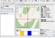
知らない道路を走るときなどはトラックログを前もって作成しておいて参照しながら走ると迷わず時間もロスせず走れていい感じです.(ブルベなどに最適)
ルートの作成にはJOSMやルートラボを利用しています.
走行後はログからデジタルカメラの写真にジオタグを埋め込んだりログや写真を見ながらOpenStreetMapに情報を入力したりしています.
- OpenStreetMap 🏛️
- GPS で色々遊ぶ – Speaker Deck 🏛️(GeoTag埋め込み方法)
そんな感じで便利に使っていたのですが,初日の出を見に行ったときのポタリングのデータを見たらデータがおかしいです.電源を入れ直すたびにその場所の標高が-になっているとかもおかしいのですが,日付が1999年05月17〜18日になっています.実際は2019年01月01日です.
GPSの1999年8月21日問題?と思いましたが,次は4月なので多分違う.
もしかしてOREGON 300は2019年のデータを扱えない?
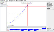
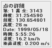
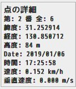
データはこんな感じで年月日と標高はおかしいですが,位置情報と時分秒は正しそうです.
$ grep trkpt ~/Nextcloud_files.matoken.org/GPS/2019-01-01.gpx |head
<trkpt lat="31.254590" lon="130.854801"><ele>28.50</ele><time>1999-05-17T20:55:26Z</time></trkpt>
<trkpt lat="31.254776" lon="130.854894"><ele>29.46</ele><time>1999-05-17T20:55:31Z</time></trkpt>
<trkpt lat="31.254912" lon="130.854996"><ele>31.38</ele><time>1999-05-17T20:55:36Z</time></trkpt>
<trkpt lat="31.254953" lon="130.855057"><ele>31.38</ele><time>1999-05-17T20:55:39Z</time></trkpt>
<trkpt lat="31.255113" lon="130.855215"><ele>33.30</ele><time>1999-05-17T20:55:46Z</time></trkpt>
<trkpt lat="31.255165" lon="130.855251"><ele>33.30</ele><time>1999-05-17T20:55:48Z</time></trkpt>
<trkpt lat="31.255219" lon="130.855322"><ele>34.26</ele><time>1999-05-17T20:55:51Z</time></trkpt>
<trkpt lat="31.255249" lon="130.855343"><ele>35.23</ele><time>1999-05-17T20:55:54Z</time></trkpt>
<trkpt lat="31.255276" lon="130.855375"><ele>34.74</ele><time>1999-05-17T20:55:56Z</time></trkpt>
<trkpt lat="31.255384" lon="130.855460"><ele>35.71</ele><time>1999-05-17T20:56:01Z</time></trkpt>
$ grep trkpt ~/Nextcloud_files.matoken.org/GPS/2019-01-01.gpx |tail
<trkpt lat="31.253258" lon="130.851111"><ele>138.09</ele><time>1999-05-18T03:57:15Z</time></trkpt>
<trkpt lat="31.253231" lon="130.851065"><ele>137.61</ele><time>1999-05-18T03:57:16Z</time></trkpt>
<trkpt lat="31.253209" lon="130.851040"><ele>136.64</ele><time>1999-05-18T03:57:17Z</time></trkpt>
<trkpt lat="31.253189" lon="130.851033"><ele>135.68</ele><time>1999-05-18T03:57:19Z</time></trkpt>
<trkpt lat="31.253162" lon="130.851021"><ele>137.13</ele><time>1999-05-18T03:57:22Z</time></trkpt>
<trkpt lat="31.253105" lon="130.850987"><ele>136.64</ele><time>1999-05-18T03:57:30Z</time></trkpt>
<trkpt lat="31.253046" lon="130.850972"><ele>136.64</ele><time>1999-05-18T03:57:36Z</time></trkpt>
<trkpt lat="31.253009" lon="130.850969"><ele>136.16</ele><time>1999-05-18T03:57:41Z</time></trkpt>
<trkpt lat="31.252981" lon="130.850972"><ele>136.64</ele><time>1999-05-18T03:57:48Z</time></trkpt>
<trkpt lat="31.252978" lon="130.850982"><ele>136.64</ele><time>1999-05-18T03:57:54Z</time></trkpt>
標高はとりあえず置いておいてsedで年月日差し替えでとりあえず写真にジオタグを付けたりするのに使えました.
$ sed -e "s/1999-05-1[7|8]/2018-12-31/g" 2019-01-01.gpx > 2019-01-01-tr.gpx
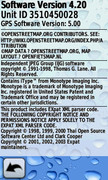
10年前の機械だからもう駄目なんだろうかと思いながらOREGON 300のFirmwareのバージョンを見ると3.01でした.
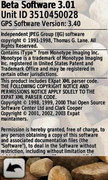
最新のFirmwareを確認すると4.20のようです.今回の件は見当たりませんがいろいろと改善されているようなので今回の件が治らないにしてもアップデートしておいたほうが良さそうです.
Changes made from version 4.10 to 4.20:
Updated magnetic Earth data
Improved GPS performance
Improved support for BirdsEye™ Satellite Imagery (each provider's imagery can be configured independently)
Increased the maximum number of supported JNX files to 250 from 200
Fixed issues with WAAS/EGNOS
Fixed issue with track navigation sometimes not adding waypoints to the Active Route list
Fixed issue with MPC map labels disappearing
Fixed shutdown on the map page when you have a geocache dashboard active and return after pressing the geocache name
Fixed issue with photo viewer not displaying correctly
Fixed issue with 3D view
Fixed issue with track navigation not adding waypoints to the Active Route list when they are exactly equal to a track point
Fixed shutdown when the device had more than the maximum number of JNX files on it
Fixed shutdown related to topographical maps and land cover text size
Fixed shutdown associated with certain custom POI files
Fixed Glide Ratio to Destination field
Fixed an issue related to adding a geocache as a point in a route
Fixed an issue with magnetic north reference and waypoint headings
Modified the 'Arriving at Destination' message banner so that it no longer appears when navigating to a geocache
Changes made from version 4.00 to 4.10:
Added support for chirp™ (Oregon 300, Oregon 400).
Fixed problem with certain custom maps.
Changes made from version 3.90 to 4.00:
Fixed issue on 3D View where vehicle could move after using the map.
Fixed issue on map page where back button would jump to the main menu.
Fixed issues with odometer distance.
Fixed shutdown while panning the map for extended periods of time.
Changes made from version 3.80 to 3.90:
Added ability to set user declination direction
Added Automatic Shaded Relief option
Added brightness adjustments for BirdsEye imagery
Added Geocache filtering. Select Setup > Geocaches to add custom filters
Added multicaching support
Improved WAAS performance
Fixed elevation profiles to always use the most detailed DEM data loaded
Fixed issue with calculator % function
Fixed issue with map POI's showing twice for a single point
Fixed issue with Oblique Mercator User grid
Fixed occasional shutdowns
Fixed spot sounding display on certain maps
Changes made from version 3.70 to 3.80:
Added BirdsEye control to profiles.
Added screen calibration option to Oregon 200.
Fixed issue changing marine modes.
Fixed map display problems.
Changes made from version 3.60 to 3.70:
Added support for Garmin BirdsEye.
Added mmHg pressure units.
Added ability to change active track color.
Added option to calibrate screen under Setup->Display.
Changes made from version 3.50 to 3.60:
Increased the map drawing range to allow maps to draw farther south.
Corrected issue with route line sometimes not drawing.
Corrected issues with marine POI.
Corrected issues with GB Discoverer maps.
Corrected issue with project waypoint bearing sometimes not showing the input value.
Changes made from version 3.40 to 3.50:
Added ability to view elevation plot of upcoming active route or currently navigated track in blue.
Added display of icons to the lists in Where To? > Waypoints and the Geocaching application.
Added phone numbers when available to POI review pages.
Added Compass, Stopwatch, Active Geocache, and Elevation Plot dashboard options.
Introduced dashboard options to the Compass and Map pages.
Improved track navigation.Visit http://garmin.blogs.com/softwareupdates/trail-tech/ for more information.
Changes made from version 3.30 to 3.40:
Added profile support for Garmin Custom Maps
Fixed lockup while using GB Discoverer maps
Changes made from version 3.20 to 3.30:
Added support for Garmin Custom Maps
Improved along road routing performance
Changes made from version 3.10 to 3.20:
Added LKS92 map datum
Added support for GPS firmware 3.70
Added support for GPI routes
Improved compass responsiveness
Fixed potential shutdown related to drawing 32-bit map points
Fixed potential issues during power on.
Changes made from version 2.80 to 3.10:
Added Waypoint Averaging application (For more information visit our new Trail Tech website at http://garmin.blogs.com/softwareupdates/trail-tech/)
Added Sight 'N Go application for the Oregon 300/400i/400c/400t
Added Man Overboard application
Added big numbers option to the trip computer
Added customizable text to unit power-on screen (see \Garmin\startup.txt)
Added ability to load maps from any img file in the Garmin directory
Added new trip computer dashboards
Added option to display four configurable data fields on the map
Added 'search near' option to Geocaches search
Added the ability to view geocache logs separate from the description
Added ability to see a list of points from the map when several points are at the same location
Added ability to edit a waypoint from the waypoint review
Added support for Custom POI database and category selection
Added distance and bearing to point when reviewing a Custom POI
Added POI subcategories
Added change location to Sun and Moon
Added change location to Hunt and Fish
Added ability to force the Oregon into mass storage mode by holding the power button for 30 seconds while plugged into a USB cable
Added NMEA 9600 baud
Improved render quality of GB Discoverer maps and maps with satellite imagery
Improved map zooming
Improved map draw speed
Improved map panning and zooming when shaded relief is turned on
Improved automatic route recalculation
Improved Custom POI spell search
Improved Main Menu setup and added option to add and remove items
Improved readability of configurable data fields
Improved display of numeric degrees and mils
Improved GPS performance at slow speeds in tree cover
Improved compass responsiveness in challenging GPS environments
Improved battery gage for NiMH batteries
Improved stability when changing profiles
Improved Wherigo stability
Improved connection reliability with Spanner
Improved Spanish keyboard
Fixed airport points not displaying on the map
Fixed lockup when a search returns no results
Fixed elevation errors when reviewing a point other than a waypoint
Increased the number of waypoints viewable from the Waypoint Manager and Where To?>Waypoints
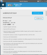
しかしアップデートにはWindows端末が必要で今まともな実機がないので面倒…….
仮想環境のWindows 10 Pro 64bitを使ってアップデートできました.
ちなみに今 $11.80 でWindows 10 Pro OEM ライセンスがセールしてたりするので環境がない人はこれを買って仮想環境に入れとくと今回みたいなときに便利です.
そして庭に出て測位してログを確認したら正しい日付のログが録れていました :)
しかし大分古いので新しいQZSS対応あたりの世代のOREGONとか欲しいですね.
OREGON だと600以降かな?カメラはいらないので600/600t/700?
- 弊社のGarminGPSはみちびき対応 GARMIN 専門店 TKA Planet 🏛️
- Garmin Oregon 200, 300, 400t, 400c, 400i, 550 & 550t Comparison – GPS Central 🏛️
環境
$ uname -m
x86_64
$ lsb_release -rd
Description:    Debian GNU/Linux buster/sid
Release:        unstable
$ dpkg-query -W gpsprune gpsbabel
gpsbabel        1.5.4-2
gpsprune        19.2-1